Supervisor(s): Prof. Tomoaki Okuda
Background
Land Use Regression (LUR) model has been widely used for modelling spatial distribution in city
scale air pollution issues, but few have conducted in Japan. To study spatial distribution of
pollutants, the Kriging method
is commonly used but it is highly constrainted by the sparseness of monitoring sites.
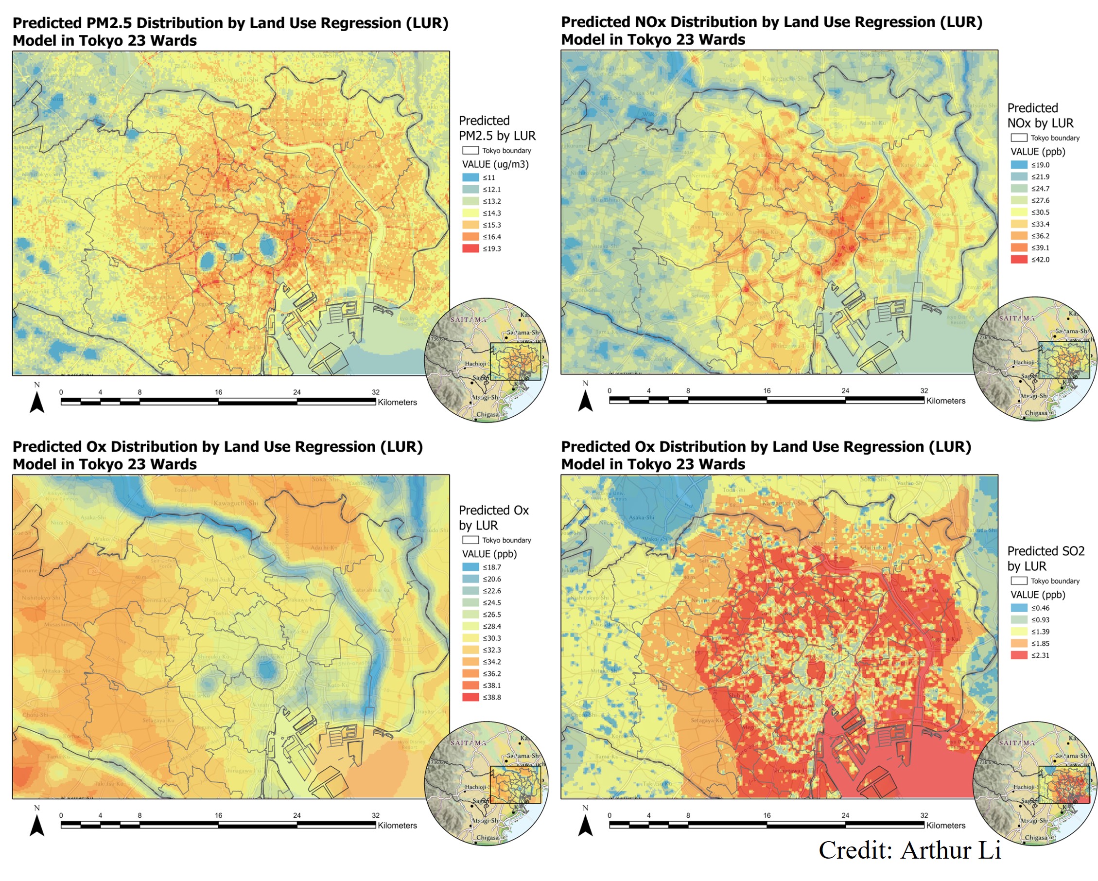
Therefore, we developed LUR models for the assessment of PM2.5, NOx, Ox, and SO2 in Tokyo
23 wards, by utilizing GIS data in Japan.
Methodology
The 2016 land use data with 100x100 m2 resolution were collected from Japanese Ministry of Land,
Infrastructure, Transport and Tourism (MILT); meanwhile,
the air pollution data were collected via Japanese air monitoring system AEROS, including annual
mean PM2.5 (μg/m3), NOx (ppb), daytime 1-hour Ox (ppb), and SO2 (ppb) data
collected by 84, 84, 46, and 33 air monitoring stations in 2016.
To develope regression equation, we applied multiple linear regression with stepwise selection
of the prediction variables. The variables were selected based on AIC value.
The models were validated by leave-one-out validation (LOOV) method.
Results
The resulting models performed adjusted R2 values for PM2.5, NOx, Ox, and SO2 of 0.41, 0.37,
0.84, and 0.55,
respectively.
The root-mean-squared errors (RMSE) for PM2.5, NOx, Ox, and SO2 LUR models were 0.93 μg/m3, 7.81
ppb, 1.05 ppb, and 0.48 ppb.
The results showed that high-rise building and dense road map in the center of Tokyo contributes
to accumulation of air pollutions.
Meanwhile, the ozone concentration in Tokyo is largely affected by the area of vegetation;
therefore, BVOC is believed to be one major limiting species for ozone formation in Tokyo.

